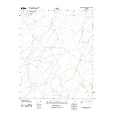
2011 Map of Steamboat Canyon
USGS Topo · Published 2011About this map
Steamboat Canyon Trading Post stands as a focal point of commerce and community in this high-desert landscape within the Fort Defiance Agency. The 2011 survey captures a network of rural routes, including Indian Rte 9054 and Bia Rd, that connect isolated homesteads and grazing lands across the Navajo Nation. The terrain is defined by the significant topographic depression of Steamboat Canyon, which cuts across the northwest corner of the quadrangle. Water sources are vital but sparse in this environment, with Joseph Spring being one of the few named perennial features. The map illustrates a contemporary pattern of land use where traditional Navajo life meets modern infrastructure, evidenced by the intersection of tribal routes and unpaved county roads that follow the natural contours of the mesas.
Find a feature on this map
10 named features on this map. Tap any name to fly to it.
Don’t see what you’re looking for? This feature index may not catch every label — zoom into the map to look around manually.
Map Details
Editions of this 2011 Steamboat Canyon Map
This is the sole edition of this map. No revisions or reprints were ever made.
Other maps of this area

1886 · Fort Defiance
USGS Topo · 1:250,000

1892 · Fort Defiance
USGS Topo · 1:250,000

1954 · Gallup
USGS Topo · 1:250,000

1958 · Gallup
USGS Topo · 1:250,000

1959 · Gallup
USGS Topo · 1:250,000

1962 · Gallup
USGS Topo · 1:250,000

1967 · Gallup
USGS Topo · 1:250,000
1972 · Steamboat Canyon
USGS Topo · 1:24,000
1972 · Toyei School
USGS Topo · 1:24,000
1972 · Greasewood
USGS Topo · 1:24,000