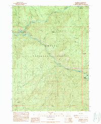
1989 Map of Steamboat
USGS Topo · Published 1990About this map
Steamboat serves as the focal point of this 1980s landscape, situated at the confluence of Canton Creek and the North Fork Umpqua River. This area within the Umpqua National Forest is defined by a deep canyon system and rugged high points like Lookout Mountain and Bachelor Butte. The map reflects a mid-century infrastructure of recreation and resource management, evidenced by several riverside retreats including Island Campground and Steamboat Falls Campground.
Find a feature on this map
46 named features on this map. Tap any name to fly to it.
Don’t see what you’re looking for? This feature index may not catch every label — zoom into the map to look around manually.
Map Details
Editions of this 1989 Steamboat Map
This is the sole edition of this map. No revisions or reprints were ever made.
Other maps of this area

1955 · Quartz Mtn
USGS Topo · 1:62,500

1955 · Red Butte
USGS Topo · 1:62,500

1955 · Mace Mtn
USGS Topo · 1:62,500

1955 · Illahee Rock
USGS Topo · 1:62,500

1958 · Roseburg
USGS Topo · 1:250,000

1959 · Roseburg
USGS Topo · 1:250,000

1978 · Diamond Lake
USGS Topo · 1:100,000
1989 · Taft Mountain
USGS Topo · 1:24,000
1989 · Scaredman Creek
USGS Topo · 1:24,000
1989 · Twin Lakes Mountain
USGS Topo · 1:24,000