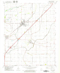
1978 Map of Steele
USGS Topo · Published 1979About this map
Steele serves as the primary hub in this corner of the Missouri Bootheel, situated at a major junction of the St Louis-San Francisco railroad and modern highways. The landscape of the Little Prairie and Cooter townships is defined by a grid of agricultural drainages and small rural settlements like Holland and Cooter. Genealogists will find significant local history preserved in several family and community burial sites, including Hopkins Cem, Frakes Cem, and Mt Zion Cem. The area's mid-century infrastructure is visible through the Steele Municipal Airport, a Radio Tower, and various Rest Areas along the interstate corridor. Near the state line with Arkansas, landmarks such as Kings Chapel and Oak Ridge Ch anchor small farming communities, while natural water features like Pemiscot Bayou provide a contrast to the engineered irrigation and Sewage Disposal Ponds that support the local population.
Find a feature on this map
26 named features on this map. Tap any name to fly to it.
Don’t see what you’re looking for? This feature index may not catch every label — zoom into the map to look around manually.
Map Details
Editions of this 1978 Steele Map
This is the sole edition of this map. No revisions or reprints were ever made.
Other maps of this area

1939 · Hales Point
USGS Topo · 1:62,500

1939 · Caruthersville
USGS Topo · 1:62,500

1939 · Blytheville
USGS Topo · 1:62,500

1940 · Hayti
USGS Topo · 1:62,500

1951 · Caruthersville
USGS Topo · 1:62,500

1952 · Hales Point
USGS Topo · 1:62,500

1955 · Hayti
USGS Topo · 1:62,500

1955 · Blytheville
USGS Topo · 1:62,500

1956 · Dyersburg
USGS Topo · 1:250,000

1956 · Blytheville
USGS Topo · 1:250,000