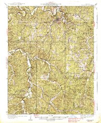
1937 Map of Steelville
USGS Topo · Published 1937About this map
Steelville serves as the focal point of this mid-1930s survey, where the St. Louis San Francisco railroad follows the winding path of Yadkin Creek toward its confluence with the Meramec River. The landscape is a network of small rural communities and isolated schools such as Lincoln Sch and Coffee Sch, reflecting the decentralized settlement patterns of the Ozark foothills. To the south, the terrain becomes more rugged within Indian Trail State Park, while family legacies are preserved in numerous burial grounds like Morrison Cem and Gregory Cem. The map illustrates a transitional era where early rail infrastructure still dictated the location of stops like Cook Station and Wesco, supporting the local agriculture and timber trade along Crooked Creek.
Find a feature on this map
51 named features on this map. Tap any name to fly to it.
Don’t see what you’re looking for? This feature index may not catch every label — zoom into the map to look around manually.
Map Details
Editions of this 1937 Steelville Map
3 editions found
Other maps of this area

1903 · Sullivan
USGS Topo · 1:125,000

1928 · Meramec Spring
USGS Topo · 1:62,500

1932 · Steelville
USGS Topo · 1:48,000

1933 · Steelville
USGS Topo · 1:62,500

1934 · Redbird
USGS Topo · 1:62,500

1937 · Steelville
USGS Topo · 1:62,500

1938 · Redbird
USGS Topo · 1:62,500

1941 · Salem
USGS Topo · 1:62,500

1941 · Stone Hill
USGS Topo · 1:62,500

1943 · Berryman
USGS Topo · 1:62,500