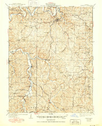
1937 Map of Steelville
USGS Topo · Published 1950About this map
Steelville serves as the hub of this Missouri Ozarks landscape, where the St Louis - San Francisco railroad network winds through the river valleys of Crawford and Dent counties. The map documents an era of small, rural community centers, many defined by their proximity to the Meramec River and its tributaries like Crooked Creek and Yadkin Creek. To the south, the extensive grounds of Indian Trail State Park mark a significant transition in land use, while the surveyor's notes indicate portions of the rail line were already being identified as St Louis - San Francisco (Abandoned). Dozens of country schools, such as Peaceful Bend Sch and Cherry Valley Sch, are scattered across the townships of Meramec, Courtois, and Osage, providing a clear record of local social geography before the consolidation of rural districts.
Find a feature on this map
68 named features on this map. Tap any name to fly to it.
Don’t see what you’re looking for? This feature index may not catch every label — zoom into the map to look around manually.
Map Details
Editions of this 1937 Steelville Map
3 editions found
Other maps of this area

1903 · Sullivan
USGS Topo · 1:125,000

1928 · Meramec Spring
USGS Topo · 1:62,500

1932 · Steelville
USGS Topo · 1:48,000

1933 · Steelville
USGS Topo · 1:62,500

1934 · Redbird
USGS Topo · 1:62,500

1937 · Steelville
USGS Topo · 1:62,500

1938 · Redbird
USGS Topo · 1:62,500

1941 · Salem
USGS Topo · 1:62,500

1941 · Stone Hill
USGS Topo · 1:62,500

1943 · Berryman
USGS Topo · 1:62,500