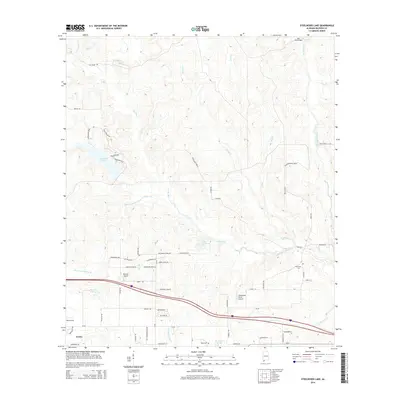
2014 Map of Steelwood Lake
USGS Topo · Published 2014About this map
The town of Loxley serves as a primary hub in this corner of Baldwin County, where the transition from agricultural fields to wooded creek basins is clearly defined. The landscape is carved by the Styx River and the Blackwater River, with smaller tributaries like Juniper Cr and Reedy Cr feeding into these larger systems. Elevated land is marked by Steelwood Ridge, which overlooks Steelwood Lake. Aviation and local industry are visible through sites like Baswell Airport, Williamson Farm Airport, and Berry Field. Genealogical researchers will find the locations of Hinote Cem and Dyes Cem particularly valuable for tracing local family histories. The drainage patterns suggest a landscape still defined by its natural watercourses, despite the expansion of rural residential roads like Trinity Wood Dr and Green Acres Rd.
Find a feature on this map
71 named features on this map. Tap any name to fly to it.
Don’t see what you’re looking for? This feature index may not catch every label — zoom into the map to look around manually.
Map Details
Editions of this 2014 Steelwood Lake Map
This is the sole edition of this map. No revisions or reprints were ever made.
Other maps of this area

1920 · Robertsdale
USGS Topo · 1:62,500

1921 · Fairhope
USGS Topo · 1:62,500

1940 · Silverhill
USGS Topo · 1:31,680

1941 · Silverhill
USGS Topo · 1:31,680

1941 · Bay Minette
USGS Topo · 1:62,500

1941 · Robertsdale
USGS Topo · 1:62,500

1941 · Fairhope
USGS Topo · 1:62,500
1942 · Silverhill
USGS Topo · 1:31,680

1942 · Dyas
USGS Topo · 1:62,500

1943 · Robertsdale
USGS Topo · 1:62,500