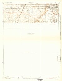
1930 Map of Steger
USGS Topo · Published 1930About this map
Michigan Central and Illinois Central rail lines converge south of Chicago in this 1927 survey, documenting a landscape at the transition between established agricultural townships and industrial expansion. The settlements of Matteson, Richton Park, South Chicago Heights, and Steger are anchored by these transportation corridors, which also include the Elgin Joliet and Eastern railroad. Significant cultural markers like St Annes Church, Immanuel School, and Calvary Cemetery are situated alongside historic thoroughfares such as Sauk Trail and the Old Lincoln Hy. The southern half of the sheet remains a preliminary unsurveyed area, while the northern portion captures the detailed street grids and early industrial footprints near Chicago Heights. The winding path of Thorn Creek provides a natural break in the otherwise systematic grid of roads and property lines across the Cook and Will County border.
Find a feature on this map
19 named features on this map. Tap any name to fly to it.
Don’t see what you’re looking for? This feature index may not catch every label — zoom into the map to look around manually.
Map Details
Editions of this 1930 Steger Map
2 editions found

Other maps of this area

1890 · Des Plaines
USGS Topo · 1:62,500

1892 · Calumet
USGS Topo · 1:62,500

1893 · Calumet
USGS Topo · 1:62,500

1894 · Des Plaines
USGS Topo · 1:62,500

1900 · Des Plaines
USGS Topo · 1:62,500

1900 · Calumet
USGS Topo · 1:62,500

1901 · Calumet
USGS Topo · 1:62,500

1901 · Des Plaines
USGS Topo · 1:62,500

1929 · Tinley Park
USGS Topo · 1:24,000

1929 · Calumet City
USGS Topo · 1:24,000