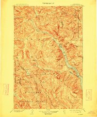
1904 Map of Stehekin
USGS Topo · Published 1913About this map
Lake Chelan serves as the focal point for this early 20th-century survey, anchoring a landscape where steep summits and deep drainage basins meet. The settlement of Stehekin sits at the northern head of the lake, acting as a gateway to the Stehekin River valley and its numerous tributaries like Agnes Creek and Company Creek. Further south along the western shoreline, Lucerne and Moore mark key points of access to the interior, where the Holden Railroad provides a rare industrial trace near Railroad Creek.
Find a feature on this map
114 named features on this map. Tap any name to fly to it.
Don’t see what you’re looking for? This feature index may not catch every label — zoom into the map to look around manually.
Map Details
Editions of this 1904 Stehekin Map
5 editions found
Other maps of this area

1899 · Glacier Peak
USGS Topo · 1:125,000

1899 · Methow
USGS Topo · 1:125,000

1901 · Glacier Peak
USGS Topo · 1:125,000

1901 · Chelan
USGS Topo · 1:125,000

1901 · Methow
USGS Topo · 1:125,000

1901 · Chiwaukum
USGS Topo · 1:125,000

1902 · Skykomish
USGS Topo · 1:125,000

1902 · Stehekin
USGS Topo · 1:125,000

1904 · Stehekin
USGS Topo · 1:125,000

1904 · Chiwaukum
USGS Topo · 1:125,000