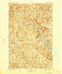
1904 Map of Stehekin
USGS Topo · Published 1925About this map
Lake Chelan anchors this high-elevation survey, appearing as a deep glacial fjord at the heart of the Chelan National Forest. The mapping reveals a landscape dominated by the high peaks of the Chelan Mountains and Wenatchee Mountains, where the Lyman Glacier still feeds the headwaters of the Chiwawa River. Early 20th-century outposts like Stehekin and Lucerne are established along the lakefront, serving as gateways to the interior's mineral prospects and high country.
Find a feature on this map
74 named features on this map. Tap any name to fly to it.
Don’t see what you’re looking for? This feature index may not catch every label — zoom into the map to look around manually.
Map Details
Editions of this 1904 Stehekin Map
5 editions found
Other maps of this area

1899 · Glacier Peak
USGS Topo · 1:125,000

1899 · Methow
USGS Topo · 1:125,000

1901 · Glacier Peak
USGS Topo · 1:125,000

1901 · Chelan
USGS Topo · 1:125,000

1901 · Methow
USGS Topo · 1:125,000

1901 · Chiwaukum
USGS Topo · 1:125,000

1902 · Skykomish
USGS Topo · 1:125,000

1902 · Stehekin
USGS Topo · 1:125,000

1904 · Stehekin
USGS Topo · 1:125,000

1904 · Chiwaukum
USGS Topo · 1:125,000