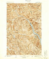
1904 Map of Stehekin
USGS Topo · Published 1925About this map
Stehekin sits at the head of Lake Chelan, serving as the gateway to the high peaks of the north Cascades at the turn of the century. This landscape is defined by the deep glacial trench of the lake and the massive drainage systems of the Stehekin River and Railroad Creek. The geography reveals a wilderness in transition, where early outposts like Lucerne and Moore provided narrow footholds for miners and travelers arriving by water. High-altitude features such as the Lyman Glacier and Bonanza Peak overlook a network of alpine lakes, including Lyman Lake and the Ice Lakes. The presence of the Boundary Line and the intersections of the Chelan National Forest, MT. Baker National Forest, and Wenatchee National Forest highlight the early administrative efforts to manage this complex terrain. Notable landmarks like Refrigerator Harbor and Rainbow Falls offer specific points of interest for those tracing the early paths through the Chelan Mountains and Entiat Mountains.
Find a feature on this map
93 named features on this map. Tap any name to fly to it.
Don’t see what you’re looking for? This feature index may not catch every label — zoom into the map to look around manually.
Map Details
Editions of this 1904 Stehekin Map
5 editions found
Other maps of this area

1899 · Glacier Peak
USGS Topo · 1:125,000

1899 · Methow
USGS Topo · 1:125,000

1901 · Glacier Peak
USGS Topo · 1:125,000

1901 · Chelan
USGS Topo · 1:125,000

1901 · Methow
USGS Topo · 1:125,000

1901 · Chiwaukum
USGS Topo · 1:125,000

1902 · Skykomish
USGS Topo · 1:125,000

1902 · Stehekin
USGS Topo · 1:125,000

1904 · Stehekin
USGS Topo · 1:125,000

1904 · Chiwaukum
USGS Topo · 1:125,000