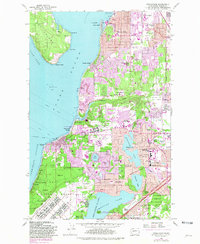
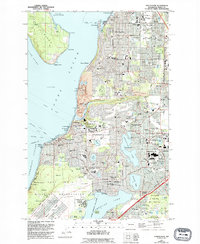
1959 Map of Steilacoom
USGS Topo · Published 1981About this map
The coastal village of Steilacoom and its neighboring communities on Puget Sound are shown at a point of significant suburban expansion in this 1959 survey, updated with 1978 photogrammetric data. The landscape is defined by its deep military and institutional roots, anchored by the Fort Lewis Military Reservation and the sprawling grounds of the Western Washington State Hospital. To the east, the rapid growth of Lakewood Center and University Place is evident in the dense network of schools like Clover Park High Sch and Wainwright Sch. The map also captures the transition from shoreline recreation at Sunnyside Beach and Sunset Beach to the major aviation infrastructure at McChord Air Force Base. Numerous inland lakes, including Gravelly Lake, American Lake, and Lake Louise, are surrounded by early residential enclaves and the Tacoma Country Club.
Find a feature on this map
73 named features on this map. Tap any name to fly to it.
Don’t see what you’re looking for? This feature index may not catch every label — zoom into the map to look around manually.
Map Details
Editions of this 1959 Steilacoom Map
5 editions found
Other maps of this area

1897 · Tacoma
USGS Topo · 1:125,000

1900 · Tacoma
USGS Topo · 1:125,000

1940 · Anderson Island
USGS Topo · 1:62,500

1941 · Tacoma South
USGS Topo · 1:62,500

1942 · Gig Harbor
USGS Topo · 1:62,500

1943 · Gig Harbor
USGS Topo · 1:62,500

1944 · Tacoma South
USGS Topo · 1:62,500

1948 · Anderson Island
USGS Topo · 1:62,500

1948 · Fort Lewis
USGS Topo · 1:24,000

1948 · Nisqually
USGS Topo · 1:24,000