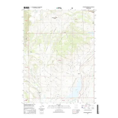
2017 Map of Steinaker Reservoir
USGS Topo · Published 2017About this map
Steinaker Reservoir serves as a focal point for this section of Uintah County, where the desert landscape meets engineered water management systems. The complex network of irrigation infrastructure is evident through the Steinaker Service Canal- Rock Point Canal, Highline Canal, and Pitt Ditch, which redirect water across the arid terrain. To the north, the boundary of the Ashley National Forest marks a transition into more dramatic topography, including the steep descents of Ashley Gorge and Big Brush Gorge. Industrial history is represented by the Stauffer Chemical Tailings Pond N and the southern Coal Mine Basin. Hikers and local historians can trace paths to Moonshine Arch or follow the winding Taylor Mountain Rd through the heart of the quadrangle, which also reveals numerous family-named landmarks like Merkley Spring and Snider Spring.
Find a feature on this map
43 named features on this map. Tap any name to fly to it.
Don’t see what you’re looking for? This feature index may not catch every label — zoom into the map to look around manually.
Map Details
Editions of this 2017 Steinaker Reservoir Map
This is the sole edition of this map. No revisions or reprints were ever made.
Other maps of this area

1885 · Ashley
USGS Topo · 1:250,000

1906 · Marsh Peak
USGS Topo · 1:125,000

1907 · Jensen
USGS Topo · 1:125,000

1908 · Marsh Peak
USGS Topo · 1:125,000

1910 · Jensen
USGS Topo · 1:125,000

1917 · Vernal
USGS Topo · 1:125,000

1950 · Burnt Cabin Gorge
USGS Topo · 1:24,000

1950 · Dyer Mountain
USGS Topo · 1:24,000

1954 · Vernal
USGS Topo · 1:250,000

1958 · Vernal
USGS Topo · 1:250,000