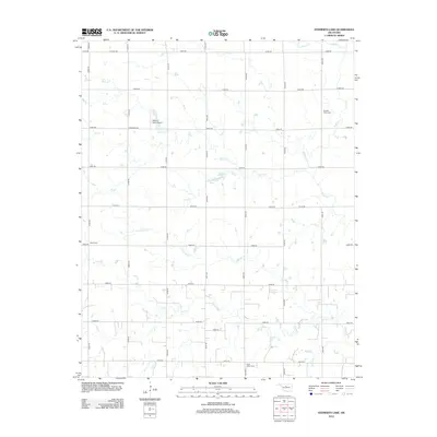
2012 Map of Steinerts Lake
USGS Topo · Published 2012About this map
Steinert’s Lake and the nearby Steinert Lakes Airport anchor this rural landscape in Garfield County, Oklahoma. The terrain is defined by a dense network of watercourses that carve through the prairie, including Rock Cr, Skeleton Cr, and Crooked Cr. These drainages dictate the placement of local roads, such as e0550 RD and n2910 RD, which follow a strict sectional grid interrupted only by the winding paths of Lyon Cr and Dry Cr. For those tracing local heritage, the map identifies three distinct burial sites: Pleasant Valley Cem, Bison Cem, and Lyon Valley Cem. The arrangement of these cemeteries and the small airstrip suggests a sparsely populated region where community life is centered around family-named landmarks and the natural hydrology of the central Oklahoma plains.
Find a feature on this map
35 named features on this map. Tap any name to fly to it.
Don’t see what you’re looking for? This feature index may not catch every label — zoom into the map to look around manually.
Map Details
Editions of this 2012 Steinerts Lake Map
This is the sole edition of this map. No revisions or reprints were ever made.
Other maps of this area

1893 · Lovell
USGS Topo · 1:62,500

1893 · Hennessey
USGS Topo · 1:62,500

1955 · Enid
USGS Topo · 1:250,000

1956 · Garber
USGS Topo · 1:62,500

1956 · Hennessey
USGS Topo · 1:62,500

1956 · Enid
USGS Topo · 1:62,500

1958 · Enid
USGS Topo · 1:250,000

1974 · Marshall West
USGS Topo · 1:24,000
1974 · Lovell
USGS Topo · 1:24,000
1982 · Bison
USGS Topo · 1:24,000