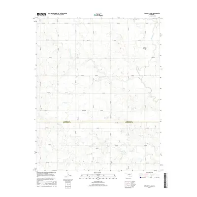
2016 Map of Steinerts Lake
USGS Topo · Published 2016About this map
Steinerts Lake sits at the center of this Oklahoma prairie landscape, where the agricultural grid of Garfield County meets Kingfisher County to the south. The terrain is defined by a dense network of seasonal drainages, including Rock Creek, Skeleton Creek, and Lyon Creek, which carve subtle paths through the sections. This 2016 survey illustrates the persistent rural character of the region, anchored by historical community landmarks such as Pleasant Valley Cemetery in the northeast and Bison Cemetery to the west. The road system, comprised of named routes like Sumner Road and Marshall Road, follows the strict section lines established by early land surveys, maintaining the traditional patchwork of the plains. Local history is etched into the landscape at Lyon Valley Cemetery, providing a focal point for genealogical research in this sparsely populated agricultural corridor.
Find a feature on this map
42 named features on this map. Tap any name to fly to it.
Don’t see what you’re looking for? This feature index may not catch every label — zoom into the map to look around manually.
Map Details
Editions of this 2016 Steinerts Lake Map
This is the sole edition of this map. No revisions or reprints were ever made.
Other maps of this area

1893 · Lovell
USGS Topo · 1:62,500

1893 · Hennessey
USGS Topo · 1:62,500

1955 · Enid
USGS Topo · 1:250,000

1956 · Garber
USGS Topo · 1:62,500

1956 · Hennessey
USGS Topo · 1:62,500

1956 · Enid
USGS Topo · 1:62,500

1958 · Enid
USGS Topo · 1:250,000

1974 · Marshall West
USGS Topo · 1:24,000
1974 · Lovell
USGS Topo · 1:24,000
1982 · Bison
USGS Topo · 1:24,000