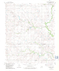
1982 Map of Steinerts Lake
USGS Topo · Published 1983About this map
Steinerts Lake and a dense network of watercourses define this section of the Oklahoma prairie along the Garfield Co Kingfisher Co line. The landscape is marked by the Old Indian Treaty Boundary, which runs east-west across the center of the sheet, providing a geographic record of historical land division. This rural area, dominated by the and Gas Field, shows the distribution of energy infrastructure alongside early 20th-century community hubs like Pleasant Valley Ch and Union Chapel. Local history and genealogy are anchored by several established burial grounds, including Bison Cem, Pleasant Valley Cem, and Lyon Valley Cem, which remain as permanent markers of the original farm families who settled near Skeleton Creek and its many tributaries, such as Hackberry Creek and Crooked Creek.
Find a feature on this map
26 named features on this map. Tap any name to fly to it.
Don’t see what you’re looking for? This feature index may not catch every label — zoom into the map to look around manually.
Map Details
Editions of this 1982 Steinerts Lake Map
This is the sole edition of this map. No revisions or reprints were ever made.
Other maps of this area

1893 · Lovell
USGS Topo · 1:62,500

1893 · Hennessey
USGS Topo · 1:62,500

1955 · Enid
USGS Topo · 1:250,000

1956 · Garber
USGS Topo · 1:62,500

1956 · Hennessey
USGS Topo · 1:62,500

1956 · Enid
USGS Topo · 1:62,500

1958 · Enid
USGS Topo · 1:250,000

1974 · Marshall West
USGS Topo · 1:24,000
1974 · Lovell
USGS Topo · 1:24,000
1982 · Bison
USGS Topo · 1:24,000