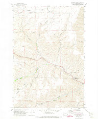
1971 Map of Stember Creek
USGS Topo · Published 1974About this map
Valentine Ridge and Alpowa Ridge dominate this high-relief landscape in southeast Washington, where deep-cut drainages reveal the intricate water patterns of Garfield and Asotin counties in the early 1970s. The terrain is defined by a series of steep gulches including Deadman Gulch, Clayton Gulch, and Pow Wah Kee Gulch, which feed into the primary drainage of Alpowa Creek. Human intervention is sparse and dictated by the geography, visible in the winding ascent of Howell Grade and the occasional Borrow Pit or Gravel Pit along the creek. Family names and local identifiers such as Megginson Gulch and Fierchinger Ridge suggest the deep-rooted agricultural and ranching history of the area. This topographic record captures the region just before modern developments, showing a network of Jeep Trails and Warm Springs that highlight the isolation of these high plateaus.
Find a feature on this map
21 named features on this map. Tap any name to fly to it.
Don’t see what you’re looking for? This feature index may not catch every label — zoom into the map to look around manually.
Map Details
Editions of this 1971 Stember Creek Map
This is the sole edition of this map. No revisions or reprints were ever made.
Other maps of this area

1910 · Pullman
USGS Topo · 1:125,000

1943 · Peola
USGS Topo · 1:62,500

1945 · Clarkston
USGS Topo · 1:62,500

1946 · Peola
USGS Topo · 1:62,500

1948 · Clarkston
USGS Topo · 1:62,500

1955 · Pullman
USGS Topo · 1:250,000

1958 · Pullman
USGS Topo · 1:250,000

1964 · Kirby
USGS Topo · 1:24,000

1964 · Colton
USGS Topo · 1:24,000

1964 · Bishop
USGS Topo · 1:24,000