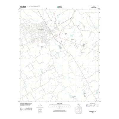
2010 Map of Stephenville
USGS Topo · Published 2010About this map
Stephenville serves as the central hub of this 2010 survey, showing the city's residential and commercial street grid as it extends toward the North Bosque River. The landscape is defined by the convergence of the North Fork North Bosque River and South Fork North Bosque River, which feed into a network of small dams and rural drainages like Pole Hollow Branch and Indian Creek. Numerous family and community burial sites are documented throughout the outlying ranch land, including the West End Cemetery near the city center and the more distant Allard Cemetery to the northeast.
Find a feature on this map
65 named features on this map. Tap any name to fly to it.
Don’t see what you’re looking for? This feature index may not catch every label — zoom into the map to look around manually.
Map Details
Editions of this 2010 Stephenville Map
This is the sole edition of this map. No revisions or reprints were ever made.
Other maps of this area

1890 · Stephenville
USGS Topo · 1:125,000

1920 · Stephenville
USGS Topo · 1:125,000

1954 · Abilene
USGS Topo · 1:250,000

1958 · Abilene
USGS Topo · 1:250,000

1961 · Johnsville
USGS Topo · 1:24,000
1961 · Alexander
USGS Topo · 1:24,000

1961 · Knob Hill
USGS Topo · 1:24,000
1961 · Clairette
USGS Topo · 1:24,000

1961 · Stephenville
USGS Topo · 1:24,000
1965 · Dublin
USGS Topo · 1:24,000