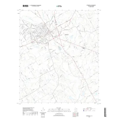
2019 Map of Stephenville
USGS Topo · Published 2019About this map
Stephenville serves as the central hub of this Erath County landscape, situated at the confluence of the S Fork N Bosque River and the N Fork N Bosque River. The town's grid expands toward the Stephenville Clark Regional Airport, while the surrounding countryside maintains its rural character with small settlements like Welcome Valley. Numerous family and community burial grounds, including Mount Olive Cem, West End Cem, and Allard Cem, are scattered across the terrain, offering significant value for genealogical research. The drainage network is particularly detailed, tracing the winding paths of the N Bosque River, Alarm Cr, and Pole Hollow Br. This survey captures the region's balance between municipal growth and the preservation of long-established rural landmarks and water resources.
Find a feature on this map
164 named features on this map. Tap any name to fly to it.
Don’t see what you’re looking for? This feature index may not catch every label — zoom into the map to look around manually.
Map Details
Editions of this 2019 Stephenville Map
This is the sole edition of this map. No revisions or reprints were ever made.
Other maps of this area

1890 · Stephenville
USGS Topo · 1:125,000

1920 · Stephenville
USGS Topo · 1:125,000

1954 · Abilene
USGS Topo · 1:250,000

1958 · Abilene
USGS Topo · 1:250,000

1961 · Johnsville
USGS Topo · 1:24,000
1961 · Alexander
USGS Topo · 1:24,000

1961 · Knob Hill
USGS Topo · 1:24,000
1961 · Clairette
USGS Topo · 1:24,000

1961 · Stephenville
USGS Topo · 1:24,000
1965 · Dublin
USGS Topo · 1:24,000