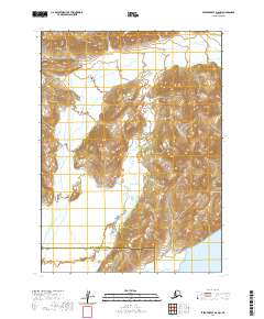
2020 Map of Stepovak Bay D-5 NW
USGS Topo · Published 2020About this map
Aleutian Range Alaska Peninsula terrain dominates this coastal region of southwest Alaska, where steep ridgelines descend toward the Pacific. The southern extent of the sheet reaches the waters of Ivanof Bay, a deep indentation in the rugged coastline that has long served as a landmark for navigation. This remote landscape is defined by its transition between administrative zones, clearly marked by the boundary between Lake and Peninsula Borough and Aleutians East Borough. The geography shown here represents the intersection of maritime influence and the towering volcanic spine of the peninsula, which remains largely devoid of modern development or permanent infrastructure beyond the natural features of the coast.
Find a feature on this map
10 named features on this map. Tap any name to fly to it.
Don’t see what you’re looking for? This feature index may not catch every label — zoom into the map to look around manually.
Map Details
Editions of this 2020 Stepovak Bay D-5 NW Map
This is the sole edition of this map. No revisions or reprints were ever made.
Other maps of this area

1951 · Stepovak Bay
USGS Topo · 1:250,000

1963 · Chignik A-6
USGS Topo · 1:63,360

1963 · Chignik A-5
USGS Topo · 1:63,360

1963 · Stepovak Bay D-6
USGS Topo · 1:63,360

1963 · Stepovak Bay D-5
USGS Topo · 1:63,360

1963 · Chignik
USGS Topo · 1:250,000

1963 · Stepovak Bay
USGS Topo · 1:250,000

1969 · Stepovak Bay
USGS Topo · 1:250,000
2020 · Stepovak Bay D-5 SW
USGS Topo · 1:25,000
2020 · Stepovak Bay D-5 NE
USGS Topo · 1:25,000