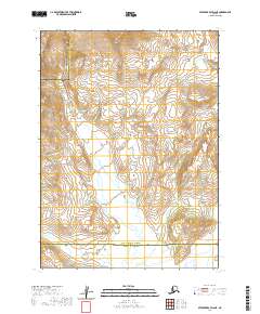
2020 Map of Stepovak Bay D-6 NE
USGS Topo · Published 2020About this map
The Aleutian Range dominates this portion of the Alaska Peninsula, where the high-altitude terrain creates a dramatic watershed for the Big River. Flowing generally southward, the river carves through a landscape defined by significant elevation changes, as indicated by the tight contour intervals across the northern half of the quadrangle. This 2020 edition provides a clear visualization of the political geography of the region, specifically the boundary line where the Aleutians East Borough meets the Lake and Peninsula Borough. The absence of developed roads or settlements emphasizes the remote, natural character of this Alaskan wilderness, where the primary features are the sweeping mountain ridges and the glacial drainage patterns of the river valley.
Find a feature on this map
11 named features on this map. Tap any name to fly to it.
Don’t see what you’re looking for? This feature index may not catch every label — zoom into the map to look around manually.
Map Details
Editions of this 2020 Stepovak Bay D-6 NE Map
This is the sole edition of this map. No revisions or reprints were ever made.
Other maps of this area

1951 · Stepovak Bay
USGS Topo · 1:250,000

1963 · Chignik A-6
USGS Topo · 1:63,360

1963 · Chignik A-5
USGS Topo · 1:63,360

1963 · Stepovak Bay D-6
USGS Topo · 1:63,360

1963 · Stepovak Bay D-5
USGS Topo · 1:63,360

1963 · Chignik
USGS Topo · 1:250,000

1963 · Stepovak Bay
USGS Topo · 1:250,000

1969 · Stepovak Bay
USGS Topo · 1:250,000
2020 · Stepovak Bay D-6 SW
USGS Topo · 1:25,000
2020 · Stepovak Bay D-5 SW
USGS Topo · 1:25,000