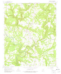
1965 Map of Steprock
USGS Topo · Published 1981About this map
Little Red River meanders across this rural White County landscape, defining the boundaries of local townships and agricultural life in the mid-1960s. The area is characterized by a dense network of country churches and small family cemeteries that serve as anchors for the scattered communities of Sunnydale and Steprock. Landmarks such as Philadelphia Cem and Olive Branch Cem provide essential data points for genealogical research, reflecting the deep-rooted settlement patterns of the region.
Find a feature on this map
48 named features on this map. Tap any name to fly to it.
Don’t see what you’re looking for? This feature index may not catch every label — zoom into the map to look around manually.
Map Details
Editions of this 1965 Steprock Map
2 editions found
Other maps of this area

1890 · Batesville
USGS Topo · 1:125,000

1891 · Batesville
USGS Topo · 1:125,000

1935 · Bald Knob
USGS Topo · 1:62,500

1953 · Memphis
USGS Topo · 1:250,000

1956 · Memphis
USGS Topo · 1:250,000

1962 · Pangburn
USGS Topo · 1:24,000

1962 · Letona
USGS Topo · 1:24,000

1965 · Pleasant Plains
USGS Topo · 1:24,000
1965 · Bald Knob
USGS Topo · 1:24,000
1965 · Judsonia
USGS Topo · 1:24,000