
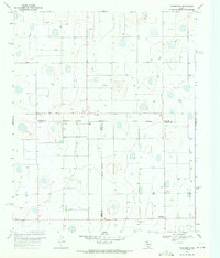
1966 Map of Sterley
USGS Topo · Published 1967About this map
The agricultural landscape of Floyd County is defined here by the meeting of two major rail lines during the mid-1960s. Lockney serves as the primary hub at the southern edge of the map, where the Atchison Topeka and Santa Fe and the Fort Worth and Denver railroads converge near industrial infrastructure like a Cotton Gin and a Station. Further north, the smaller settlement of Sterley sits at another rail junction, marked by its Water Tank and Storage Bins.
Find a feature on this map
14 named features on this map. Tap any name to fly to it.
Don’t see what you’re looking for? This feature index may not catch every label — zoom into the map to look around manually.
Map Details
Editions of this 1966 Sterley Map
This is the sole edition of this map. No revisions or reprints were ever made.
Other maps of this area

1954 · Plainview
USGS Topo · 1:250,000

1958 · Plainview
USGS Topo · 1:250,000

1965 · Whiteley
USGS Topo · 1:24,000

1965 · Lockney SE
USGS Topo · 1:24,000

1965 · Silverton SW
USGS Topo · 1:24,000

1965 · Lockney
USGS Topo · 1:24,000

1966 · South Plains
USGS Topo · 1:24,000

1968 · Plainview SE
USGS Topo · 1:24,000

1968 · Aiken
USGS Topo · 1:24,000
1969 · Providence
USGS Topo · 1:24,000