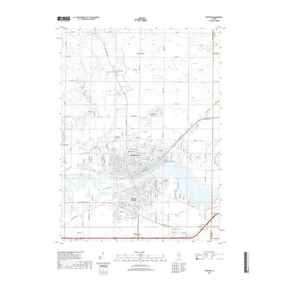
2018 Map of Sterling
USGS Topo · Published 2018About this map
The Rock River serves as the central artery of this Illinois landscape, physically dividing the twin cities of Sterling and Rock Falls. This 2018 survey documents the intricate grid of the urban core, which transitions into an expansive agricultural periphery defined by the township and range lines of the Public Land Survey System. Genealogical interest is high given the numerous burial grounds documented, including the Science Ridge Mennonite Cem to the north and the extensive Riverside Cem and Calvary Cem on the Sterling bluffs. To the south, the engineering of the Union Drainage Ditch and the presence of Crystal Lake illustrate the managed hydrology of the lowlands below the river bend. Small watercourses like Jordan Cr and Elkhorn Creek meander through the northern fields, while Ave G Island sits prominently in the river channel between the two primary municipalities.
Find a feature on this map
140 named features on this map. Tap any name to fly to it.
Don’t see what you’re looking for? This feature index may not catch every label — zoom into the map to look around manually.
Map Details
Editions of this 2018 Sterling Map
This is the sole edition of this map. No revisions or reprints were ever made.
Other maps of this area

1930 · Woodsung
USGS Topo · 1:48,000

1932 · Prophetstown
USGS Topo · 1:48,000

1934 · Morrison
USGS Topo · 1:48,000

1936 · Prophetstown
USGS Topo · 1:62,500

1940 · Morrison
USGS Topo · 1:62,500

1946 · Sterling
USGS Topo · 1:62,500

1948 · Sterling
USGS Topo · 1:62,500

1949 · Walnut
USGS Topo · 1:62,500

1958 · Aurora
USGS Topo · 1:250,000

1961 · Aurora
USGS Topo · 1:250,000