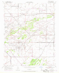
1954 Map of Stevens
USGS Topo · Published 1970About this map
The Kern River and its intricate network of irrigation and industry dominate this Central Valley landscape, characterized by the intense development of the petroleum industry during the mid-20th century. Named settlements like Stevens and Ten Section are situated within a landscape defined more by extraction and water management than traditional residential growth. Large industrial zones such as the Strand Oil Field and the Bellevue Oil Field are clearly demarcated, showing the density of wells and storage tanks that fueled the local economy.
Find a feature on this map
24 named features on this map. Tap any name to fly to it.
Don’t see what you’re looking for? This feature index may not catch every label — zoom into the map to look around manually.
Map Details
Editions of this 1954 Stevens Map
4 editions found
Other maps of this area

1906 · Bakersfield
USGS Topo · 1:62,500

1910 · Buena Vista Lake
USGS Topo · 1:125,000

1912 · Buena Vista Lake
USGS Topo · 1:125,000

1929 · Stevens
USGS Topo · 1:31,680

1929 · Coles Levee
USGS Topo · 1:31,680

1929 · Mouth of Kern
USGS Topo · 1:31,680

1930 · Millux
USGS Topo · 1:31,680

1930 · Rosedale
USGS Topo · 1:31,680

1930 · Conner
USGS Topo · 1:31,680

1930 · Oildale
USGS Topo · 1:31,680