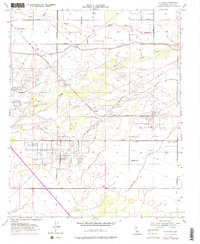
1954 Map of Stevens
USGS Topo · Published 1976About this map
The industrial character of the San Joaquin Valley is on full display in this mid-century topographic survey, where oil production and water management dominate the landscape. The Ten Section Oil Field and the Ten Section Refinery serve as major focal points, connected to the wider region by the Southern Pacific railroad and a dense network of pipelines. At the center of this activity sits Stevens, a small settlement near the base of Stevens Hill, while the Canfield Ranch and its associated Canfield Ranch Oil Field occupy the eastern plains.
Find a feature on this map
24 named features on this map. Tap any name to fly to it.
Don’t see what you’re looking for? This feature index may not catch every label — zoom into the map to look around manually.
Map Details
Editions of this 1954 Stevens Map
4 editions found
Other maps of this area

1906 · Bakersfield
USGS Topo · 1:62,500

1910 · Buena Vista Lake
USGS Topo · 1:125,000

1912 · Buena Vista Lake
USGS Topo · 1:125,000

1929 · Stevens
USGS Topo · 1:31,680

1929 · Coles Levee
USGS Topo · 1:31,680

1929 · Mouth of Kern
USGS Topo · 1:31,680

1930 · Millux
USGS Topo · 1:31,680

1930 · Rosedale
USGS Topo · 1:31,680

1930 · Conner
USGS Topo · 1:31,680

1930 · Oildale
USGS Topo · 1:31,680