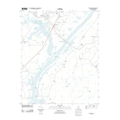
2011 Map of Stevenson
USGS Topo · Published 2011About this map
Guntersville Lake dominates this portion of Jackson County, where the Tennessee River's impoundment shapes the modern landscape around Stevenson. The map documents a deep history of river crossings and family landholdings, visible in the numerous small burial grounds such as Wimberley Cemetery, Foshee Cemetery, and Caperton Cemetery. The transition from river-based transport to modern infrastructure is marked by the Captain John Snodgrass Bridge, which spans the water near the site of the historic Caperton Ferry.
Find a feature on this map
87 named features on this map. Tap any name to fly to it.
Don’t see what you’re looking for? This feature index may not catch every label — zoom into the map to look around manually.
Map Details
Editions of this 2011 Stevenson Map
This is the sole edition of this map. No revisions or reprints were ever made.
Other maps of this area

1886 · Stevenson
USGS Topo · 1:125,000

1892 · Stevenson
USGS Topo · 1:125,000

1895 · Stevenson
USGS Topo · 1:125,000

1936 · Ider
USGS Topo · 1:24,000

1936 · Bridgeport
USGS Topo · 1:24,000

1936 · Wannville
USGS Topo · 1:24,000

1936 · Flat Rock
USGS Topo · 1:24,000

1936 · Hollywood
USGS Topo · 1:24,000

1936 · Stevenson
USGS Topo · 1:24,000
1936 · Henagar
USGS Topo · 1:24,000