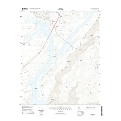
2014 Map of Stevenson
USGS Topo · Published 2014About this map
Stevenson and New Town anchor this Jackson County landscape where the Tennessee River's waters form Guntersville Lake. The settlement patterns here are deeply tied to the terrain, with small communities like Yucca, Fabius, and Old Fabius positioned near the rising slopes of Sand Mountain. Significant local landmarks include the Captain John Snodgrass Bridge crossing the lake and the distinct elevations of Pinder Hill and Coalbank Point.
Find a feature on this map
96 named features on this map. Tap any name to fly to it.
Don’t see what you’re looking for? This feature index may not catch every label — zoom into the map to look around manually.
Map Details
Editions of this 2014 Stevenson Map
This is the sole edition of this map. No revisions or reprints were ever made.
Other maps of this area

1886 · Stevenson
USGS Topo · 1:125,000

1892 · Stevenson
USGS Topo · 1:125,000

1895 · Stevenson
USGS Topo · 1:125,000

1936 · Ider
USGS Topo · 1:24,000

1936 · Bridgeport
USGS Topo · 1:24,000

1936 · Wannville
USGS Topo · 1:24,000

1936 · Flat Rock
USGS Topo · 1:24,000

1936 · Hollywood
USGS Topo · 1:24,000

1936 · Stevenson
USGS Topo · 1:24,000
1936 · Henagar
USGS Topo · 1:24,000