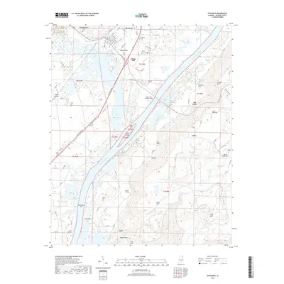
2018 Map of Stevenson
USGS Topo · Published 2018About this map
Stevenson serves as a focal point along the Tennessee River, where the grid of Broad St and Kentucky Ave meets the rail corridor. The river landscape is significantly defined by the presence of Guntersville Lake and large river features such as Crow Creek Island and Coffee Bend Bar. Local history and genealogy are deeply embedded in the land, with numerous family burial grounds including Wimberley Cem, Foshee Cem, and Caperton Cem scattered across the flats and riverbanks.
Find a feature on this map
103 named features on this map. Tap any name to fly to it.
Don’t see what you’re looking for? This feature index may not catch every label — zoom into the map to look around manually.
Map Details
Editions of this 2018 Stevenson Map
This is the sole edition of this map. No revisions or reprints were ever made.
Other maps of this area

1886 · Stevenson
USGS Topo · 1:125,000

1892 · Stevenson
USGS Topo · 1:125,000

1895 · Stevenson
USGS Topo · 1:125,000

1936 · Ider
USGS Topo · 1:24,000

1936 · Bridgeport
USGS Topo · 1:24,000

1936 · Wannville
USGS Topo · 1:24,000

1936 · Flat Rock
USGS Topo · 1:24,000

1936 · Hollywood
USGS Topo · 1:24,000

1936 · Stevenson
USGS Topo · 1:24,000
1936 · Henagar
USGS Topo · 1:24,000