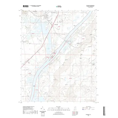
2020 Map of Stevenson
USGS Topo · Published 2020About this map
The town of Stevenson serves as a central hub on this Jackson County landscape, situated near the sweeping waters of Guntersville Lake. The area's settlement history is deeply recorded through numerous family burial sites, including the Stogsdill-Wynn Cem, Foshee Cem, and Wimberley Cem. To the east, the terrain rises sharply toward Sand Mountain, while smaller communities like Fabius, Old Fabius, and Yucca dot the hills and hollows. The Captain John Snodgrass Bridge spans the Tennessee River waters, connecting the more developed western valley to the intricate landscape of Norwood Cove and Coalbank Point. This 2020 record captures the intricate network of local roads such as Co RD 45 and John T Reid Pkwy that link these longstanding upland and riverine communities.
Find a feature on this map
105 named features on this map. Tap any name to fly to it.
Don’t see what you’re looking for? This feature index may not catch every label — zoom into the map to look around manually.
Map Details
Editions of this 2020 Stevenson Map
This is the sole edition of this map. No revisions or reprints were ever made.
Other maps of this area

1886 · Stevenson
USGS Topo · 1:125,000

1892 · Stevenson
USGS Topo · 1:125,000

1895 · Stevenson
USGS Topo · 1:125,000

1936 · Ider
USGS Topo · 1:24,000

1936 · Bridgeport
USGS Topo · 1:24,000

1936 · Wannville
USGS Topo · 1:24,000

1936 · Flat Rock
USGS Topo · 1:24,000

1936 · Hollywood
USGS Topo · 1:24,000

1936 · Stevenson
USGS Topo · 1:24,000
1936 · Henagar
USGS Topo · 1:24,000