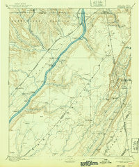
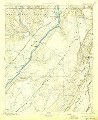
1895 Map of Stevenson
USGS Topo · Published 1940About this map
The Tennessee River serves as the central artery through this late nineteenth-century landscape, flanked by the massive elevations of the Cumberland Plateau and Lookout Mountain. Transportation in the valley relied heavily on a series of historic river crossings, including Island Creek Ferry, Caperton Ferry, and Sublet Ferry, which connected the isolated communities on Sand Mountain to the rail hubs. The Nashville Chattanooga and St. Louis R.R. Main Line and the Memphis and Charleston R.R. converge at Stevenson, a vital junction for the region's commerce.
Find a feature on this map
101 named features on this map. Tap any name to fly to it.
Don’t see what you’re looking for? This feature index may not catch every label — zoom into the map to look around manually.
Map Details
Editions of this 1895 Stevenson Map
6 editions found

Other maps of this area

1885 · Gadsden
USGS Topo · 1:125,000

1886 · Ringgold
USGS Topo · 1:125,000

1886 · Rome
USGS Topo · 1:125,000

1886 · Stevenson
USGS Topo · 1:125,000

1888 · Gadsden
USGS Topo · 1:125,000

1888 · Chattanooga
USGS Topo · 1:125,000

1888 · Scottsboro
USGS Topo · 1:125,000

1892 · Ringgold
USGS Topo · 1:125,000

1892 · Scottsboro
USGS Topo · 1:125,000

1892 · Stevenson
USGS Topo · 1:125,000