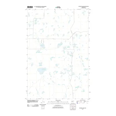
2010 Map of Stewart Lake
USGS Topo · Published 2010About this map
Glacial lakes and wetlands dominate this portion of Crow Wing County, where the landscape is defined by an intricate network of water bodies and marshy lowlands. At the center of the sheet, Stewart Lake and Island Lake are prominent features, flanked by the unique identifiers of Big Cranberry Lake and Little Cranberry Lake. The map reveals a transition between dense hydrography and a sparse road network that follows the natural contours of the land. Northward, the topography is punctuated by Peterson Lake, Stony Lake, and the curiously named Dirty House Lake. Transportation in the area relies on routes like Old Grade Rd and County Hwy-54, which navigate the spaces between basins like Blind Lake and smaller tributaries such as Thompson Creek. The arrangement of these water features suggests a terrain shaped by receding ice, leaving behind the kettle lakes and bogs characteristic of the region.
Find a feature on this map
27 named features on this map. Tap any name to fly to it.
Don’t see what you’re looking for? This feature index may not catch every label — zoom into the map to look around manually.
Map Details
Editions of this 2010 Stewart Lake Map
This is the sole edition of this map. No revisions or reprints were ever made.
Other maps of this area

1953 · Brainerd
USGS Topo · 1:250,000

1957 · Brainerd
USGS Topo · 1:250,000

1958 · Brainerd
USGS Topo · 1:250,000

1959 · Lower Whitefish Lake
USGS Topo · 1:24,000

1959 · Jenkins
USGS Topo · 1:24,000

1960 · Cross Lake
USGS Topo · 1:24,000

1965 · Brainerd
USGS Topo · 1:250,000

1970 · Laura Lake
USGS Topo · 1:24,000
1970 · Mitchell Lake
USGS Topo · 1:24,000

1970 · Woman Lake
USGS Topo · 1:24,000