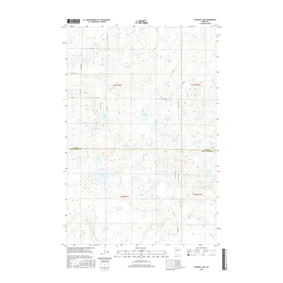
2016 Map of Stewart Lake
USGS Topo · Published 2016About this map
The Minnesota lake country of the Northwoods is meticulously detailed in this survey of the borderlands between Cass and Crow Wing counties. This glacial landscape is defined by its high density of kettle lakes and wetlands, where large basins like Stewart Lake and Island Lake are surrounded by smaller, uniquely named bodies of water such as Dirty House Lake, Boiler Lake, and Lily Lake. The transportation network is a mixture of established county routes like Cass Co Rd 56 and localized trails such as Old Grade Trl NE and Wolf Lake Trl, which navigate the complex terrain. The drainage of the area is further evidenced by Thompson Cr in the south, while the northern sections are dominated by the expanse of Peterson Lake and Blind Lake. The grid of the Public Land Survey System provides a rigid framework over this fluid landscape of marshes and timberland.
Find a feature on this map
33 named features on this map. Tap any name to fly to it.
Don’t see what you’re looking for? This feature index may not catch every label — zoom into the map to look around manually.
Map Details
Editions of this 2016 Stewart Lake Map
This is the sole edition of this map. No revisions or reprints were ever made.
Other maps of this area

1953 · Brainerd
USGS Topo · 1:250,000

1957 · Brainerd
USGS Topo · 1:250,000

1958 · Brainerd
USGS Topo · 1:250,000

1959 · Lower Whitefish Lake
USGS Topo · 1:24,000

1959 · Jenkins
USGS Topo · 1:24,000

1960 · Cross Lake
USGS Topo · 1:24,000

1965 · Brainerd
USGS Topo · 1:250,000

1970 · Laura Lake
USGS Topo · 1:24,000
1970 · Mitchell Lake
USGS Topo · 1:24,000

1970 · Woman Lake
USGS Topo · 1:24,000