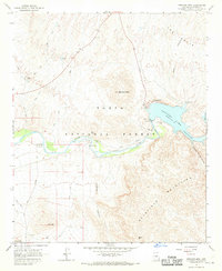
1964 Map of Stewart Mtn.
USGS Topo · Published 1970About this map
Saguaro Lake dominates the central landscape of this 1960s survey, formed by the impoundment of the Salt River. The map highlights the essential infrastructure of the era, including the Stewart Mtn Dam and its associated Powerhouse, which together managed water resources and power for the growing Arizona interior. The surrounding territory within the Tonto National Forest is characterized by its complex topography, featuring the Goldfield Mountains to the south and Stewart Mtn rising above the northern shore.
Find a feature on this map
32 named features on this map. Tap any name to fly to it.
Don’t see what you’re looking for? This feature index may not catch every label — zoom into the map to look around manually.
Map Details
Editions of this 1964 Stewart Mtn. Map
4 editions found
Other maps of this area

1900 · Florence
USGS Topo · 1:125,000

1902 · Florence
USGS Topo · 1:125,000

1904 · Desert Well
USGS Topo · 1:62,500

1904 · Ft. McDowell
USGS Topo · 1:62,500

1906 · Ft. McDowell
USGS Topo · 1:62,500

1906 · Desert Well
USGS Topo · 1:62,500

1907 · Roosevelt
USGS Topo · 1:125,000

1909 · Four Peaks
USGS Topo · 1:125,000

1912 · Roosevelt
USGS Topo · 1:125,000

1930 · Cave Creek
USGS Topo · 1:125,000