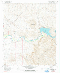
1964 Map of Stewart Mtn.
USGS Topo · Published 1990About this map
Saguaro Lake and the Salt River dominate this desert landscape, revealing the critical infrastructure of the mid-century Salt River Project. The Stewart Dam and its adjacent Stewart Dam Powerhouse stand as the focal point of the area's water management and hydroelectric development. Within the Tonto National Forest, the map details early recreational and administrative sites including the Blue Point Ranger Sta, the Blue Point Forest Camp, and the historic crossing at Sheep Bridge. This period shows a rugged terrain marked by the Goldfield Mountains and the unique geomorphology of The Rolls, networked by the Bush Highway and numerous named canyons. The presence of the Gaging Station and various picnic areas highlights the dual role of the river as both a utility and a destination for early 1960s Arizona travelers.
Find a feature on this map
32 named features on this map. Tap any name to fly to it.
Don’t see what you’re looking for? This feature index may not catch every label — zoom into the map to look around manually.
Map Details
Editions of this 1964 Stewart Mtn. Map
4 editions found
Other maps of this area

1900 · Florence
USGS Topo · 1:125,000

1902 · Florence
USGS Topo · 1:125,000

1904 · Desert Well
USGS Topo · 1:62,500

1904 · Ft. McDowell
USGS Topo · 1:62,500

1906 · Ft. McDowell
USGS Topo · 1:62,500

1906 · Desert Well
USGS Topo · 1:62,500

1907 · Roosevelt
USGS Topo · 1:125,000

1909 · Four Peaks
USGS Topo · 1:125,000

1912 · Roosevelt
USGS Topo · 1:125,000

1930 · Cave Creek
USGS Topo · 1:125,000