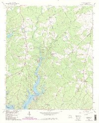
1964 Map of Stewart
USGS Topo · Published 1985About this map
The Alcovy River and South River converge to form the northern reaches of Jackson Lake, creating a landscape of winding peninsulas and deep coves along the Newton and Jasper county line. The terrain is defined by family-named landforms such as Parker Neck, Price Neck, and Kitchen Neck, reflecting a heritage of riparian landholding. While the southern portion of the map is dominated by the reservoir's recreation-focused developments like Alcovy Shores and the FFA and FHA Camp, the northern upland retains its rural character. Small rural crossroads and communities like Stewart and Hardys Crossroad are anchored by several country churches, including Heard Ch and Macedonia Ch. Historical industrial remnants are evident at Factory Shoals and the Newton Factory Cem, pointing to the early water-powered mills that once operated along the river before the lake was formed.
Find a feature on this map
69 named features on this map. Tap any name to fly to it.
Don’t see what you’re looking for? This feature index may not catch every label — zoom into the map to look around manually.
Map Details
Editions of this 1964 Stewart Map
3 editions found
Other maps of this area

1896 · Monroe
USGS Topo · 1:125,000

1953 · Athens
USGS Topo · 1:250,000

1958 · Athens
USGS Topo · 1:250,000

1959 · Athens
USGS Topo · 1:250,000

1963 · Athens
USGS Topo · 1:250,000

1964 · Lloyd Shoals Dam
USGS Topo · 1:24,000
1964 · Jackson
USGS Topo · 1:24,000

1964 · Stewart
USGS Topo · 1:24,000

1964 · Worthville
USGS Topo · 1:24,000

1964 · Porterdale
USGS Topo · 1:24,000