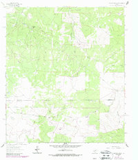
1962 Map of Stewart Ranch
USGS Topo · Published 1987About this map
The Dry Llano River carves its way through this portion of the Texas Hill Country, defining a landscape of intermittent drainage and isolated ranching outposts. This 1962 survey, updated in the late 1980s, captures the rural infrastructure of Sutton and Edwards counties, where cattle ranching and energy extraction intersect. Named homesteads like Stewart Ranch and Miers Ranch are central to the region's geography, connected by the rugged path of Bond Road and a network of unimproved trails. The terrain is marked by significant ephemeral watercourses, including Tenmile Draw and Rattlesnake Draw, which dominate the topographic relief. Industrial development is evident through a prominent Pumping Station, a Gas Well, and several pipelines that traverse the limestone plateaus, reflecting the mid-century expansion of the local oil and gas industry alongside traditional land use.
Find a feature on this map
13 named features on this map. Tap any name to fly to it.
Don’t see what you’re looking for? This feature index may not catch every label — zoom into the map to look around manually.
Map Details
Editions of this 1962 Stewart Ranch Map
2 editions found
Other maps of this area

1893 · Rock Springs
USGS Topo · 1:125,000

1954 · Sonora
USGS Topo · 1:250,000

1958 · Sonora
USGS Topo · 1:250,000

1962 · Stewart Ranch
USGS Topo · 1:24,000
1962 · Bundy Ranch
USGS Topo · 1:24,000

1963 · Steen Lake
USGS Topo · 1:24,000

1963 · Harrison Ranch
USGS Topo · 1:24,000

1963 · Live Oak Draw
USGS Topo · 1:24,000
1963 · Fort Terrett Ranch
USGS Topo · 1:24,000

1970 · Ray Lake NW
USGS Topo · 1:24,000