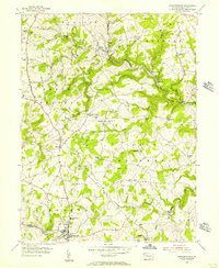
1953 Map of Stewartstown
USGS Topo · Published 1956About this map
The Maryland and Pennsylvania railroad winds through the rolling landscape of York County, connecting rural centers like Felton and Stewartstown. This mid-century survey reveals a highly localized economy still defined by traditional water-powered sites such as Sechrist Mill, Bacon Mill, and Hyson Mill. These landmarks, along with many small crossroad settlements like Winterstown and Cross Roads, illustrate the transition from a nineteenth-century mill-and-rail hub to a modern agricultural district. The map is particularly rich for genealogical research, documenting numerous community anchors including St Pauls Ch, Lebanon Ch Cem, and the Old Roundhill Cem. Dense woodland remains concentrated along the branching tributaries of Muddy Creek, while the surrounding plateaus of Windsor and Hopewell townships are dominated by open fields and farmsteads.
Find a feature on this map
52 named features on this map. Tap any name to fly to it.
Don’t see what you’re looking for? This feature index may not catch every label — zoom into the map to look around manually.
Map Details
Editions of this 1953 Stewartstown Map
4 editions found
Other maps of this area

1900 · Parkton
USGS Topo · 1:62,500

1901 · Belair
USGS Topo · 1:62,500

1902 · Parkton
USGS Topo · 1:62,500

1908 · York
USGS Topo · 1:62,500

1910 · York
USGS Topo · 1:62,500

1912 · Mc Calls Ferry
USGS Topo · 1:62,500

1942 · Bel Air
USGS Topo · 1:62,500

1943 · Mc Calls Ferry
USGS Topo · 1:62,500

1944 · New Freedom
USGS Topo · 1:31,680

1944 · Norrisville
USGS Topo · 1:31,680