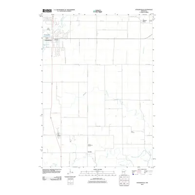
2010 Map of Stewartville
USGS Topo · Published 2010About this map
Stewartville serves as the primary hub of this 2010 landscape, where the Stewartville Dam controls the waters of the North Branch Root River to form Lake Florence. The area is defined by a deep-rooted network of rural settlements and agricultural land, reaching from Pleasant Grove in the northeast down toward Racine and Hamilton in the south. Genealogists and local historians will find several well-documented burial grounds, including the Saint Bernard Cemetery, Woodlawn Cemetery, and the Hamilton Congregational Cemetery. The drainage of the land is marked by numerous winding waterways such as Kedron Creek and Bear Creek, which cut across a grid of secondary roads like County Hwy-2 and 30th Ave SE. The presence of dedicated post offices in both Stewartville and Racine highlights these towns as enduring centers of community life in Olmsted County.
Find a feature on this map
39 named features on this map. Tap any name to fly to it.
Don’t see what you’re looking for? This feature index may not catch every label — zoom into the map to look around manually.
Map Details
Editions of this 2010 Stewartville Map
This is the sole edition of this map. No revisions or reprints were ever made.
Other maps of this area

1954 · Mason City
USGS Topo · 1:250,000

1955 · Stewartville
USGS Topo · 1:62,500

1955 · High Forest
USGS Topo · 1:62,500

1957 · Mason City
USGS Topo · 1:250,000

1958 · Mason City
USGS Topo · 1:250,000

1965 · Wykoff
USGS Topo · 1:24,000

1965 · Spring Valley
USGS Topo · 1:24,000

1965 · Grand Meadow
USGS Topo · 1:24,000
1974 · High Forest
USGS Topo · 1:24,000
1974 · Salem Corners
USGS Topo · 1:24,000