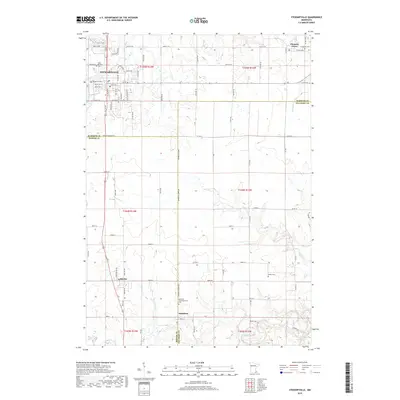
2019 Map of Stewartville
USGS Topo · Published 2019About this map
The Stewartville hub and the tri-county intersection of Olmsted, Fillmore, and Mower counties define this recent topographical landscape. Settled clusters like Pleasant Grove and Racine appear along the modern road network, while the small community of Hamilton sits further south near the winding path of Bear Creek. The geography is characterized by several drainage systems, notably Kedron Creek and the Root River, which have shaped the local terrain.
Find a feature on this map
47 named features on this map. Tap any name to fly to it.
Don’t see what you’re looking for? This feature index may not catch every label — zoom into the map to look around manually.
Map Details
Editions of this 2019 Stewartville Map
This is the sole edition of this map. No revisions or reprints were ever made.
Other maps of this area

1954 · Mason City
USGS Topo · 1:250,000

1955 · Stewartville
USGS Topo · 1:62,500

1955 · High Forest
USGS Topo · 1:62,500

1957 · Mason City
USGS Topo · 1:250,000

1958 · Mason City
USGS Topo · 1:250,000

1965 · Wykoff
USGS Topo · 1:24,000

1965 · Spring Valley
USGS Topo · 1:24,000

1965 · Grand Meadow
USGS Topo · 1:24,000
1974 · High Forest
USGS Topo · 1:24,000
1974 · Salem Corners
USGS Topo · 1:24,000