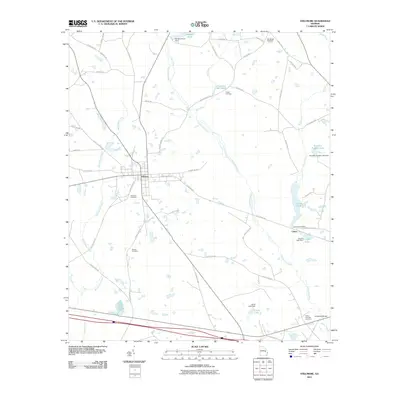
2011 Map of Stillmore
USGS Topo · Published 2011About this map
Stillmore and the surrounding Emanuel County landscape are defined by the winding course of the Canoochee River and a network of agricultural roads and ancestral sites. In this 2011 survey, the town of Stillmore serves as the central hub, with the Stillmore Cemetery and the intersection of the Stillmore Hwy and E 3rd Ave marking its historic core. To the east, the small settlement of Canoe sits near the namesake Canoe Pond, illustrating the localized water management common to the region with numerous impoundments like Cooper Lake and Brantley Trapnell Lake. Family names are deeply etched into the geography, seen in sites like the Cowart Cemetery near Cowarts Mill Pond and the Warren Cemetery located south of town. The presence of routes such as Sunbury Trl and Blackbird Trl hints at older transit corridors through this timber and farming country, while Strawfield Bridge provides a crossing at the southeastern edge of the quadrangle.
Find a feature on this map
59 named features on this map. Tap any name to fly to it.
Don’t see what you’re looking for? This feature index may not catch every label — zoom into the map to look around manually.
Map Details
Editions of this 2011 Stillmore Map
This is the sole edition of this map. No revisions or reprints were ever made.
Other maps of this area

1957 · Macon
USGS Topo · 1:250,000

1958 · Macon
USGS Topo · 1:250,000

1964 · Macon
USGS Topo · 1:250,000

1970 · Cobbtown
USGS Topo · 1:24,000
1970 · Metter
USGS Topo · 1:24,000
1970 · Metter SE
USGS Topo · 1:24,000

1970 · Nunez
USGS Topo · 1:24,000

1970 · Oak Park
USGS Topo · 1:24,000

1971 · Stillmore
USGS Topo · 1:24,000

1971 · Swainsboro
USGS Topo · 1:24,000