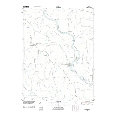
2010 Map of Stockport
USGS Topo · Published 2010About this map
The Muskingum River snakes through the center of this landscape, anchoring riverfront settlements like Stockport and Hooksburg. This 2010 topographic record highlights the complex relationship between the winding waterway and the steep relief of Patterson Ridge and McCoy Ridge. To the west, the settlement of Pennsville remains a focal point for the surrounding rural area, marked by the Pennsville Post Office and several historic burial sites, including the Friends Burial Ground. Numerous small tributaries like Bald Eagle Run and Aldridge Run carve through the terrain, illustrating the drainage patterns that shaped the region's development. Genealogists will find a high concentration of burial sites throughout the quadrangle, from the Infirmary Cemetery near Lovell to the Blackemar Cemetery in the southeast, providing a detailed map of the area's ancestral heritage.
Find a feature on this map
105 named features on this map. Tap any name to fly to it.
Don’t see what you’re looking for? This feature index may not catch every label — zoom into the map to look around manually.
Map Details
Editions of this 2010 Stockport Map
This is the sole edition of this map. No revisions or reprints were ever made.
Other maps of this area

1902 · Parkersburg
USGS Topo · 1:62,500

1904 · Parkersburg
USGS Topo · 1:62,500

1904 · Chesterhill
USGS Topo · 1:62,500

1906 · Chesterhill
USGS Topo · 1:62,500

1909 · Caldwell
USGS Topo · 1:62,500

1910 · Mc Connelsville
USGS Topo · 1:62,500

1912 · Caldwell
USGS Topo · 1:62,500

1949 · Clarksburg
USGS Topo · 1:250,000

1956 · Clarksburg
USGS Topo · 1:250,000

1960 · Watertown
USGS Topo · 1:24,000