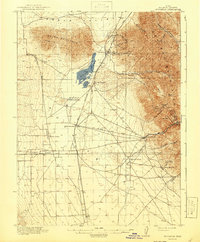
1918 Map of Stockton
USGS Topo · Published 1941About this map
Rush Lake and the western slopes of the Oquirrh Mountains dominate this region during the early twentieth century. The landscape is defined by a distinct transition from the high-altitude mining districts in the east to the agricultural and transit-oriented settlements of the valley. Mining activity is concentrated in steep terrain, with unnamed numbered mines scattered near Gisborn, Ophir, and the community of West Mercur. These industrial outposts are connected to the valley floor via the St John and Ophir Road, which descends through Ophir Canyon. On the flatter terrain to the west, the Salt Lake and Los Angeles RR anchors the local economy, serving St John Sta and providing a vital link for several established ranching operations, including Bates Ranch, Youngs Ranch, and Morgan Ranch. This survey captures a moment when the rugged canyons were still actively being worked for mineral wealth while the valley floor supported a network of small towns like Stockton, Clover, and Saint John.
Find a feature on this map
45 named features on this map. Tap any name to fly to it.
Don’t see what you’re looking for? This feature index may not catch every label — zoom into the map to look around manually.
Map Details
Editions of this 1918 Stockton Map
4 editions found
Other maps of this area

1885 · Tooele Valley
USGS Topo · 1:250,000

1915 · Fairfield
USGS Topo · 1:62,500

1917 · Fairfield
USGS Topo · 1:62,500

1918 · Stockton
USGS Topo · 1:62,500

1947 · Fivemile Pass
USGS Topo · 1:62,500

1949 · Fivemile Pass
USGS Topo · 1:24,000

1952 · Bingham Canyon
USGS Topo · 1:24,000

1953 · Tooele
USGS Topo · 1:250,000

1955 · Timpie
USGS Topo · 1:62,500

1955 · Deseret Peak
USGS Topo · 1:62,500