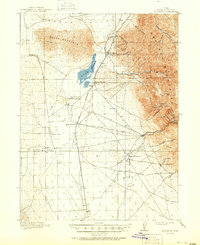
1918 Map of Stockton
USGS Topo · Published 1950About this map
Oquirrh Mountains mineral deposits and ranching operations dominate this 1916 survey of Tooele County. The industrial activity of the era is evidenced by numbered mine sites such as No 6 near Gisborn and the cluster of operations around Ophir and West Mercur in the eastern canyons. Between the peaks and the waters of Rush Lake, a network of early transportation routes like the St John and Ophir RR and the Salt Lake and Los Angeles Road connect remote outposts. The valley floor is dotted with family-named landmarks including Youngs Ranch, Morgan Ranch, and Bates Ranch, reflecting the agricultural settlement patterns that coexisted with the region's mining booms. Early rail stops like St John Sta and the small communities of Stockton and Clover anchor the landscape, providing a clear view of the region's development before mid-century modernization.
Find a feature on this map
48 named features on this map. Tap any name to fly to it.
Don’t see what you’re looking for? This feature index may not catch every label — zoom into the map to look around manually.
Map Details
Editions of this 1918 Stockton Map
4 editions found
Other maps of this area

1885 · Tooele Valley
USGS Topo · 1:250,000

1915 · Fairfield
USGS Topo · 1:62,500

1917 · Fairfield
USGS Topo · 1:62,500

1918 · Stockton
USGS Topo · 1:62,500

1947 · Fivemile Pass
USGS Topo · 1:62,500

1949 · Fivemile Pass
USGS Topo · 1:24,000

1952 · Bingham Canyon
USGS Topo · 1:24,000

1953 · Tooele
USGS Topo · 1:250,000

1955 · Timpie
USGS Topo · 1:62,500

1955 · Deseret Peak
USGS Topo · 1:62,500