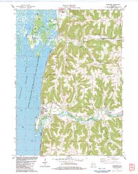
1983 Map of Stoddard
USGS Topo · Published 1983About this map
The Burlington Northern railroad corridor hugs the eastern shore of the Mississippi River, serving as a distinct boundary between the backwaters of the Upper Mississippi River Wild Life and Fish Refuge and the steep blufflands of Vernon and La Crosse counties. The village of Stoddard sits at the base of these bluffs, where the landscape transitions into a complex network of deep valleys and narrow ridges. These geographical features, locally known as coulees, define the settlement patterns of the region, with small communities like Pleasant Valley and Maple Grove tucked into the upland folds.
Find a feature on this map
52 named features on this map. Tap any name to fly to it.
Don’t see what you’re looking for? This feature index may not catch every label — zoom into the map to look around manually.
Map Details
Editions of this 1983 Stoddard Map
This is the sole edition of this map. No revisions or reprints were ever made.
Other maps of this area

1926 · Stoddard
USGS Topo · 1:62,500

1927 · La Crosse
USGS Topo · 1:62,500

1930 · La Crescent
USGS Topo · 1:62,500

1930 · La Crosse
USGS Topo · 1:62,500

1956 · Brownsville
USGS Topo · 1:62,500

1956 · La Crescent
USGS Topo · 1:62,500

1958 · La Crosse
USGS Topo · 1:250,000

1961 · La Crosse
USGS Topo · 1:250,000
1963 · St. Joseph
USGS Topo · 1:24,000
1963 · La Crosse
USGS Topo · 1:24,000