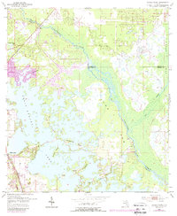
1954 Map of Stokes Ferry
USGS Topo · Published 1988About this map
Lake Tsala Apopka dominates this 1950s landscape, illustrating the complex hydrology of the Withlacoochee River basin where the boundaries of Marion, Citrus, and Sumter counties meet. The settlement of Hernando sits on the western shore of the lake, served by the Seaboard railroad line. The map highlights a transition from the structured street grids of early developments like the trailer park near the shoreline to the wilder, marshy reaches of Gum Swamp and Gum Slough to the east.
Find a feature on this map
22 named features on this map. Tap any name to fly to it.
Don’t see what you’re looking for? This feature index may not catch every label — zoom into the map to look around manually.
Map Details
Editions of this 1954 Stokes Ferry Map
5 editions found
Other maps of this area

1892 · Dunnellon
USGS Topo · 1:62,500

1893 · Panasoffkee
USGS Topo · 1:62,500

1894 · Dunnellon
USGS Topo · 1:62,500

1895 · Tsala Apopka
USGS Topo · 1:62,500

1895 · Panasoffkee
USGS Topo · 1:62,500

1895 · Ocala
USGS Topo · 1:62,500

1954 · Lecanto
USGS Topo · 1:24,000

1954 · Holder
USGS Topo · 1:24,000

1954 · Tsala Apopka NE
USGS Topo · 1:24,000

1954 · Dunnellon
USGS Topo · 1:24,000