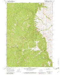
1967 Map of Stone Mountain
USGS Topo · Published 1982About this map
The eastern edge of the Bighorn National Forest dominates this landscape, where the high ridges of Stone Mountain and Pheasant drop sharply into the creek-fed basins of Johnson County. The map details a complex network of water management, showcasing the Jim Crow Ditch, Mowry Basin Ditch, and Rock Creek Ditch as they divert flow across the lower elevations near the H F Bar Ranch. This transition from mountain to basin is marked by dramatic terrain features like Red Canyon and the curiously named The Speedway, illustrating the challenging topography encountered by early ranching and irrigation efforts in the region. A labyrinth of Pack Trails and Jeep Trails provides the only access into the high timber, following watercourses such as Balm of Gilead Creek and North Fork Rock Creek.
Find a feature on this map
31 named features on this map. Tap any name to fly to it.
Don’t see what you’re looking for? This feature index may not catch every label — zoom into the map to look around manually.
Map Details
Editions of this 1967 Stone Mountain Map
2 editions found
Other maps of this area

1895 · Dayton
USGS Topo · 1:125,000

1899 · Cloud peak
USGS Topo · 1:125,000

1900 · Fort McKinney
USGS Topo · 1:125,000

1901 · Cloud Peak
USGS Topo · 1:125,000

1901 · Dayton
USGS Topo · 1:125,000

1903 · Fort McKinney
USGS Topo · 1:125,000

1909 · Sheridan
USGS Topo · 1:125,000

1911 · Sheridan
USGS Topo · 1:125,000

1955 · Sheridan
USGS Topo · 1:250,000

1958 · Sheridan
USGS Topo · 1:250,000