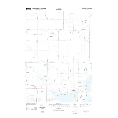
2013 Map of Stonebank
USGS Topo · Published 2013About this map
Stonebank and the surrounding lake country of Waukesha County appear here in a transition toward modern suburban and recreational land use. The Ashippun River and Oconomowoc River systems anchor the landscape, feeding into significant water bodies such as Okauchee Lake, North Lake, and Moose Lake. The industrial legacy of the region's waterways is still evident in labels for Monterey Millpond and Alderly Millpond, while agricultural heritage persists through named holdings like Twilight Farms and Culleden Farm. The presence of the Oconomowoc Airport and developments like Stone Ridge Farms reflect the early 21st-century growth of this region between the historic rural hamlets of Mapleton and Monterey. This survey captures the complex drainage patterns and island features like McDowell Island that define the area's geography.
Find a feature on this map
93 named features on this map. Tap any name to fly to it.
Don’t see what you’re looking for? This feature index may not catch every label — zoom into the map to look around manually.
Map Details
Editions of this 2013 Stonebank Map
This is the sole edition of this map. No revisions or reprints were ever made.
Other maps of this area

1892 · Watertown
USGS Topo · 1:62,500

1892 · Oconomowoc
USGS Topo · 1:62,500

1894 · Watertown
USGS Topo · 1:62,500

1904 · Hartford
USGS Topo · 1:62,500

1909 · Oconomowoc
USGS Topo · 1:62,500

1955 · Horicon
USGS Topo · 1:62,500

1957 · Madison
USGS Topo · 1:250,000
1959 · Hartland
USGS Topo · 1:24,000

1959 · Ixonia
USGS Topo · 1:24,000
1959 · Oconomowoc East
USGS Topo · 1:24,000