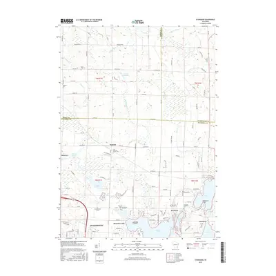
2015 Map of Stonebank
USGS Topo · Published 2015About this map
Okauchee Lake and the Oconomowoc River define the southern landscape of this 2015 study, an area where glacial water bodies meet early settlement patterns. This region of Wisconsin, spanning parts of Dodge, Washington, and Waukesha Counties, contains a dense network of local history markers, particularly through its well-preserved cemeteries. These include the Mount Hope Cem near the headwaters of Dawson Cr and the Stone Bank Presbyterian Cem in the hamlet of Stonebank.
Find a feature on this map
108 named features on this map. Tap any name to fly to it.
Don’t see what you’re looking for? This feature index may not catch every label — zoom into the map to look around manually.
Map Details
Editions of this 2015 Stonebank Map
This is the sole edition of this map. No revisions or reprints were ever made.
Other maps of this area

1892 · Watertown
USGS Topo · 1:62,500

1892 · Oconomowoc
USGS Topo · 1:62,500

1894 · Watertown
USGS Topo · 1:62,500

1904 · Hartford
USGS Topo · 1:62,500

1909 · Oconomowoc
USGS Topo · 1:62,500

1955 · Horicon
USGS Topo · 1:62,500

1957 · Madison
USGS Topo · 1:250,000
1959 · Hartland
USGS Topo · 1:24,000

1959 · Ixonia
USGS Topo · 1:24,000
1959 · Oconomowoc East
USGS Topo · 1:24,000