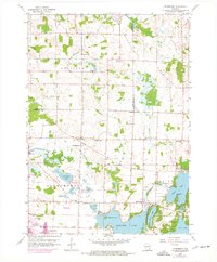
1959 Map of Stonebank
USGS Topo · Published 1972About this map
Glacial lakes and small hamlets dominate this mid-century landscape where Dodge, Washington, and Waukesha counties meet. The Ashippun River and Oconomowoc River wind through a region defined by water and early rural infrastructure, including local schools like Mapleton Sch and Pleasant View Sch. Settlement patterns are anchored by several historic parishes, such as St Paul Ch and St Olaf Ch, alongside smaller crossroads like Alderley and Monterey.
Find a feature on this map
40 named features on this map. Tap any name to fly to it.
Don’t see what you’re looking for? This feature index may not catch every label — zoom into the map to look around manually.
Map Details
Editions of this 1959 Stonebank Map
4 editions found
Other maps of this area

1892 · Watertown
USGS Topo · 1:62,500

1892 · Oconomowoc
USGS Topo · 1:62,500

1894 · Watertown
USGS Topo · 1:62,500

1904 · Hartford
USGS Topo · 1:62,500

1909 · Oconomowoc
USGS Topo · 1:62,500

1955 · Horicon
USGS Topo · 1:62,500

1957 · Madison
USGS Topo · 1:250,000
1959 · Hartland
USGS Topo · 1:24,000

1959 · Ixonia
USGS Topo · 1:24,000
1959 · Oconomowoc East
USGS Topo · 1:24,000