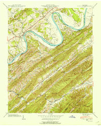
1939 Map of Stony Point
USGS Topo · Published 1954About this map
Holston River dominates the upper half of this 1939 survey, winding through dramatic bends like Phipps Bend and Christian Bend while defining the low-lying agricultural corridors of Hawkins Co and Greene Co. The landscape transitions sharply from the fertile river bottoms and islands like Miller Island to the steep, parallel ridges of Little Goshen Mountain and Short Mountain. The settlement pattern follows the Lee Highway and Southern Railway through Stony Point and Surgoinsville, where social life centered on institutions like Maxwell Academy and New Providence Ch. Further south, the map reveals a more isolated upland economy characterized by the Lumber RR near Van Hill and the presence of Mowls Mill along Beech Creek. These details, alongside family-named landmarks like Dykes Store and numerous hillside cemeteries, provide a clear view of East Tennessee's rural character before mid-century modernization.
Find a feature on this map
62 named features on this map. Tap any name to fly to it.
Don’t see what you’re looking for? This feature index may not catch every label — zoom into the map to look around manually.
Map Details
Editions of this 1939 Stony Point Map
3 editions found

Other maps of this area

1892 · Greeneville
USGS Topo · 1:125,000

1894 · Estillville
USGS Topo · 1:125,000

1896 · Greeneville
USGS Topo · 1:125,000

1904 · Greeneville
USGS Topo · 1:125,000

1935 · Surgoinsville
USGS Topo · 1:48,000

1935 · Baileyton
USGS Topo · 1:24,000

1935 · Lovelace
USGS Topo · 1:24,000

1935 · Moggasin
USGS Topo · 1:48,000

1935 · Looneys Gap
USGS Topo · 1:24,000

1935 · McCloud
USGS Topo · 1:24,000